Photo by David Ward
Angela Kross, PhD.
- Associate Professor, Geography, Planning and Environment
Are you the profile owner?
Sign in to editResearch areas: Remote sensing; Geographic Information Systems; Ecosystem structure, function and services; vegetation dynamics; land use change and climate change; biodiversity,
Contact information
Biography
Biography
Angela Kross is a fulltime-faculty in Remote Sensing and Geospatial Technologies, she has obtained an M.Sc in Geographic Information Science / Remote Sensing from Wageningen University and Research Centre in the Netherlands and a Ph.D in Physical Geography / Remote Sensing from McGill University. Prior to joining Concordia in August 2015, she was a post doctoral researcher at Agriculture and Agri-Food Canada. In her research she uses GIS and Remote Sensing technologies in combination with ground measurements and models to answer questions related to ecosystem processes, vegetation development and land use change in response to anthropogenic and natural events, such as agriculture practices, mining activities and climate change.
Teaching activities
Courses
Introduction to Geographic Information Systems (GEOG363)
Advanced Geographic Information Systems (GEOG463)
Remote Sensing (GEOG465)
Summer GIS Certificate
Advanced Quantitative Research Methods (HENV 610)
Student supervision
Jennifer Donnini, MSc, Remote sensing of forestbiodiversity, September 2023 – Ongoing
Michael Ekwe, PhD, Monitoring corn and soybeanleaf area index and above-ground biomass mass using multi-sensor data, September 2022 - Ongoing
Lingshan Li, PhD, The impact of spatialpatterns of urban green infrastructure on urban microclimate and air quality(co-supervision with Carly Ziter and Ursula Eicker), January 2020 - Ongoing
Yann Quash, MSc., Assessing the impact of gold mining on forest coverin the Surinamese Amazon from 1997 to 2019: A semi-automated satellite-basedapproach, September 2020 –March 2023
David Fargey, MSc., Remote sensing applied toplant phenology monitoring, September 2019
Jason Langford, BA/Honours, Measuring the effect ofMontreal’s Rooftop Albedo on Urban Heat, July 2021 – May 2022
Eric Laflamme, BA/Honours, Monitoring treeline changes inQuebec: phenology, landcover and climate, July 2019 – May 2020
Jacques Simon- Mayer, BSc/Honours, Mapping and monitoring surface water chlorophyll αusing satellite imagery: investigation of industrial impacts on western lakeErie’s water quality, September 2019 - April 2020
Olivier Makuch, BSc/Honours, Monitoring tundra phenologyacross Canada, July 2019 – May 2020
Sayeda Kulsum, MEnv, Environmental impactassessment for agricultural production systems in Canada (independent project), Completed September 2018
Evelyn Znoj, MEnv, Artificial neural networkapplied to environmental impact assessment phases (part of the controlled tiledrainage - calculate your benefits project), December 2017 - April 2018
Gurpreet Bharaj Kaur, MEnv, Geospatial technologiesapplied to the environmental impact assessment of agriculture, May 2017 - May 2018
Yuka Makiyama, MEnv, Prioritizing placement ofconservation buffers in the Shire River Basin in Malawi, Completed August2017
Victoria Curl, MEnv, Using artificial neuralnetworks as a prediction tool in environmental impact assessment, CompletedJanuary 2017
Research activities
1. Assess and monitor environmental impacts ofagriculture
-Advancing multi-sensor and multi-source dataintegration methods for improved characterization and quantification of cropdevelopment and its impacts on the environment (NSERC)
-Controlled tile drainage – calculate your benefits (AAFC)
2. Assess and monitor landscape phenology
-Caractérisation et évaluation des changements dela phénologie végétale en réponse aux changements environnementaux à l'aide dela télédétection (FRQNT)
3. Knowledge mobilization strategies and outreach
https://demo.gatewaygeomatics.com/ctd/
4. Remote sensing of biodiversity
5. Earth observation for modelling local to global vegetation and environmental characteristics
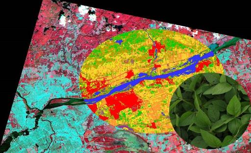
From a pretty picture to land cover information to biophysical properties!
Publications
Refereed publications
- Cole JR, Koen EL, Pedersen EJ, Gallo JA,Kross A, and Jaeger JAG (2023). Impacts of anthropogenic land transformation onspecies-specific habitat amount, fragmentation, and connectivity in theAdirondack-to-Laurentians (A2L) transboundary wildlife linkage between 2000 and2015: Implications for conservation and ecological restoration. LandscapeEcology: 38, 2591–2621. IF 5.2 (0). https://doi.org/10.1007/s10980-023-01727-6
-
Cole, J.R., Kross, A. & Jaeger, J.A.G.(2022) Monitoring changes in landscape structure in theAdirondack-to-Laurentians (A2L) transboundary wildlife linkage between 1992 and2018: Identifying priority areas for conservation and restoration. Landsc Ecol38, 383–408. IF 5.2 (1). https://doi.org/10.1007/s10980-022-01561-2
-
Kross, A., Kaur*, G., & Jaeger, J. A.G. (2022).A geospatial framework for the assessment and monitoring ofenvironmental impacts of agriculture. Environmental Impact Assessment Review, 97,106851. IF 7.9 (10) https://doi.org/10.1016/j.eiar.2022.106851
-
Pourali, M., Townsend, C., Kross, A.,Guindon, A., & Jaeger, J. A. (2022). Urban sprawl in Canada: Values in all33 Census Metropolitan Areas and corresponding 469 Census Subdivisions between1991 and 2011. Data in Brief, 41, 107941. IF 1.2 (3). https://doi.org/10.1016/j.dib.2022.107941
-
Pourali, Mehrdokht ; Townsend, Craig;Kross, Angela; Guindon, Alex ; Jaeger, Jochen (2022), Urban sprawl in Canada:Values in all 33 census metropolitan areas and corresponding 469 censussubdivisions between 1991 and 2011. (Data). Mendeley Data, V1, https://doi.org/10.17632/r3z83jb292.
-
Kross A, Znoj E*, Callegari D*, Kaur G*,Sunohara M, Lapen DR, & McNairn H (2020). Using artificial neural networksand remotely sensed data to evaluate the relative importance of variables forprediction of within-field corn and soybean yields. Remote Sensing, 12 (25),2230. IF 5. https://doi.org/10.3390/rs12142230.
-
Kross A, Seaguist JW & Roulet NT(2016). Light use efficiency of peatlands: variability and suitability formodeling ecosystem production. Remote Sensing of Environment, 183, 239 - 249. IF13.5 (24). http://dx.doi.org/10.1016/j.rse.2016.05.004.
-
Kross A., Lapen DR, McNairn H, Sunohara M,Champagne C & Wilkes G (2015). Satellite and in situ derived corn andsoybean biomass and leaf area index: Response to controlled tile drainage undervarying weather conditions. Agricultural Water Management, 160, 118-131. IF. 6.7(21). https://doi.org/10.1016/j.agwat.2015.06.007.
-
Kross A, McNairn H, Lapen DR, Sunohara M,Champagne C (2015). Assessment of RapidEye vegetation indices for estimation ofleaf area index and biomass in corn and soybean crops. International Journal ofApplied Earth Observation and Geoinformation, 34, 235 - 248. IF 7.5 (436). http://dx.doi.org/10.1016/j.jag.2014.08.002.
-
Kross A, Roulet, NT, Moore TR, Lafleur PM,Humphreys ER, Seaquist JW, Flanagan LB, Aurela M (2014). Phenology and its rolein carbon dioxide exchange processes in northern peatlands. JGR-Biogeosciences,119, 1370 - 1384. IF 3.7 (35). http://dx.doi.org/10.1002/2014JG002666.
-
McNairn H, Kross A, Lapen DR, Caves R,Shang J (2014). Early season monitoring of corn and soybeans with TerraSAR-Xand RADARSAT-2. International Journal of Applied Earth Observation andGeoinformation, 28, 252 – 259 IF 7.5 (162). http://dx.doi.org/10.1016/j.jag.2013.12.015.
-
Kross A, Seaquist JW, Roulet NT, FernandesR, Sonnentag O (2013). Estimating carbon dioxide exchange rates at contrastingnorthern peatlands using MODIS satellite data. Remote Sensing of Environment,137, 234 - 243. IF 13.5 (35). http://dx.doi.org/10.1016/j.rse.2013.06.014.
-
Kross A, Fernandes R, Seaquist JW, BeaubienE (2011). The effect of the temporal resolution of NDVI data on season onsetdates and trends across Canadian broadleaf forests. Remote Sensing ofEnvironment, 115, 1564 - 1575. IF 13.5 (91). http://dx.doi.org/10.1016/j.rse.2011.02.015.
Non-refereed publications
-
Kaur G*, Kross A, Callegari D*, Sunohara M,Van Vliet L, Rudy H, Lapen DR & McNairn H (2018). Spatial decision supportsystem: Controlled tile drainage – calculate your benefits. In Proceedings ofthe 14th International Conference on Precision Agriculture (unpaginated,online). Monticello, IL: International Society of Precision Agriculture. (0).
-
Kross A, Znoj E*, Callegari D*, Kaur G*,Sunohara M, Van Vliet L, Rudy H, Lapen DR & McNairn H (2018). Evaluation ofan artificial neural network approach for prediction of corn and soybean yield.In Proceedings of the 14th International Conference on Precision Agriculture(unpaginated, online). Monticello, IL: International Society of PrecisionAgriculture. (9).