Canadian, provincial, and municipal geospatial data
This page lists geospatial data (GIS data) that is produced by the Governments of Canada, Quebec, Ontario, and the City of Montreal. The geospatial data on this website consists of: census geography files, topographic map data, digital elevation models, cadastral data and general mapping data. Geospatial data, also known as GIS Data, can be used to create maps and analyse geographic information. To view and analyse this data, a Geographic Information System software is required.
Geoindex
Geoindex is a shared platform used by Quebec universities to disseminate geospatial data products. It includes numerous datasets produced by the Quebec government such as cadastral data, orthophotos, topographic data and much more. Users can perform keyword searches and use the interactive map to locate, visualize and download datasets in various formats and projections.
Geophoto module
The Geophoto module of Geoindex is a shared catalogue of aerial photographs owned by Quebec Universities and other organizations such as the ministère de l'Énergie et des Ressources naturelles (MERN) and Bibliotheque et Archives nationales (BAnQ). Inventoried photos are available in print and digital formats. Members of the Concordia community can search, visualize and download (in the case of digitized items) photographs. Print photos can be obtained through Interlibrary loans.
Canadian, provincial, and municipal government geospatial data
A web portal that allows users to explore and download, without charge, geospatial data and maps of Canada. Search can be done by using various interactive tools or by browsing a directory of products.
NOTE: an easy way to identify the geographic area you are interested in along with its National Topographic System (NTS) code is through the Geospatial Data Extraction Tool. Under "Overlay reference layers", choose the National Tiling System Grid Coverage.
Geospatial product Index
The Geospatial product index is the best tool to download raster data (topographic maps); vector data (CanVec, hydrography road and rail networks, land cover); elevation data (various elevation models invlusind the HRDEM ); and imagery (orthoimages and satellite images).
Most popular datasets
The most popular products available from include:
CanVec
CanVec contains more than 60 topographic features classes organized into 8 themes: Transport Features, Administrative Features, Hydro Features, Land Features, Manmade Features, Elevation Features, Resource Management Features and Toponymic Features.
High Resolution Digital Elevation Model (HRDEM)
HRDEM includes a Digital Terrain Model (DTM), a Digital Surface Model (DSM) and other derived data. For DTM datasets, derived data available are slope, aspect, shaded relief, color relief and color shaded relief maps and for DSM datasets, derived data available are shaded relief, color relief and color shaded relief maps.
In the southern part of the country (south of the productive forest line), DTM and DSM datasets are generated from airborne LiDAR data. They are offered at a 1 m or 2 m resolution and projected to the UTM NAD83 (CSRS) coordinate system and the corresponding zones. The datasets at a 1 m resolution cover an area of 10 km x 10 km while datasets at a 2 m resolution cover an area of 20 km by 20 km
Toporama
"Toporama is a topographic reference product produced by NRCan using CanVec data. Toporama originates from the best available data sources covering the entire Canadian landmass at a scale of 1: 50 000. Toporama displays this data in a representative (symbolic) manner allowing for easy identification. Format available: GeoTiff."
Atlas of Canada
The Atlas offers free small scale data for North America, Canada and Canadian provinces.
Census Spatial Information Products
These include Road Network Files, Dissemination Geographies Relationship File (that provides unique identifiers allowing comparison between geographic areas at various geographic levels using the Dissemination Geography Unique Identifiers (DGUIDs)) and Census Boundary Files that represent the different census geographies in Canada: Provinces, Census Divisions, Census Subdivisions, Census Tracts, Dissemination Areas, etc. These data are available for all censuses from 2001 to 2021.
Data from the Government of Quebec
Data the Ministère des ressources naturelles et forêts (MRNF) and other ministries, including orthophotographs and Lidar datasets, are now publicly available from the Données Québec website.
Most of these datasets are also available from the Geoindex platform.
Adresses Quebec
Adresses Quebec is a suite of products avaialble as vector files in SHP format. It includes AQgeo, a flat file model providing official location and classification of the complete road network for the province of Quebec along with road names, address ranges and postal codes; AQcarto a cartographic layer including administrative boundaries for municipalities and boroughs as well as a hydrographic layer; AQpro, a relational databases providing address ranges and working in conjunction with AQgeobati (individual addresses and locations represented as points) and AQdirection which includes road information such as one-ways, speed limits and turn restrictions.
For a detailed descriptions of these products see the user guide (in French only).
All the layers from Adresses Quebec are avaiable in Geoindex
Cadastral Data
This dataset describes individual lots in the Province of Quebec. It includes geographic files in shapefile (shp) format and attribute tables consisting of the administrative description of the lots, such as the municipality, the owner, the number of the property title and correspondence with old lots.
Available in Geoindex
Flood-Risk Areas
This geodatabase (.gdb) includes flood-risk zones (2 years, 20 years, 100 years), high water marks (cotes de crue) and historical data on floods for the province of Quebec. The attribute tables also list associated reports. For more information, consult the data dictionary (in French only).
The data can be visualized on this interactive map which also links to the various reports and pdf maps.
Also available in Geoindex
LiDAR Data
LiDAR (Light Detection and Ranging) is an airborne, laser-based remote sensing technology that measures distance by illuminating a target and analysing the reflecting light. It is used to produce digital terrain models and mosaic datasets.
LiDAR and DTMs from the Government of Quebec
Historical and recent Lidar datasets and associated Digital Terrain Models (DTM) from the Ministère des ressources naturelles et forêts (MRNF) are now available on the Données Québec website.
Other LiDAR datasets
We have acquired LiDAR datasets for the following areas (most of those datasets are available through Geoindex):
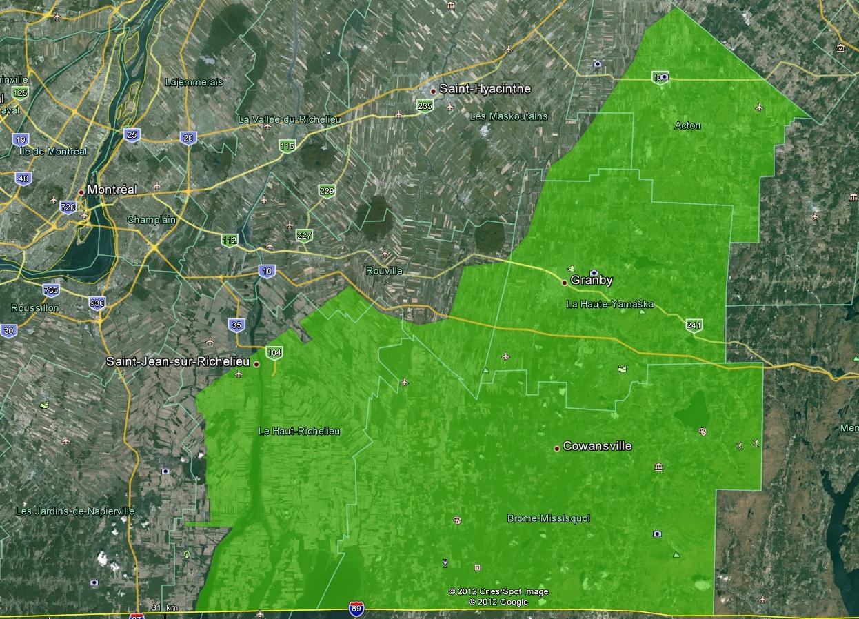
- Laval, Laurentides, Lanaudiere, Monteregie, Estrie (2017)
Only some specific sectors of these regions are covered (see map). For more details, see the tile indexes (zipped shp): Index 1; Index 2
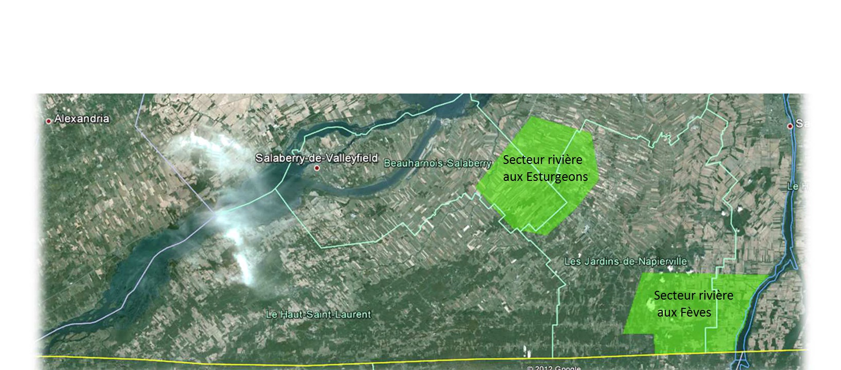
- Monteregie Sud-Est (2013).
Data available as raw or classified.
See map. Download the index of tiles (zipped SHP for ArcGIS) - Rivière aux Esturgeons et Secteur rivière aux Fèves (2010).
Data available as raw or classified (ground and above-ground)
See map. Download the index of tiles (zipped SHP for ArcGIS) - Vallée-du-Haut-St-Laurent (2011) See map. The data is available as:
- Raw data. Download the index (.shp));
- Classified data (ground and above-ground). Download the index (.shp).
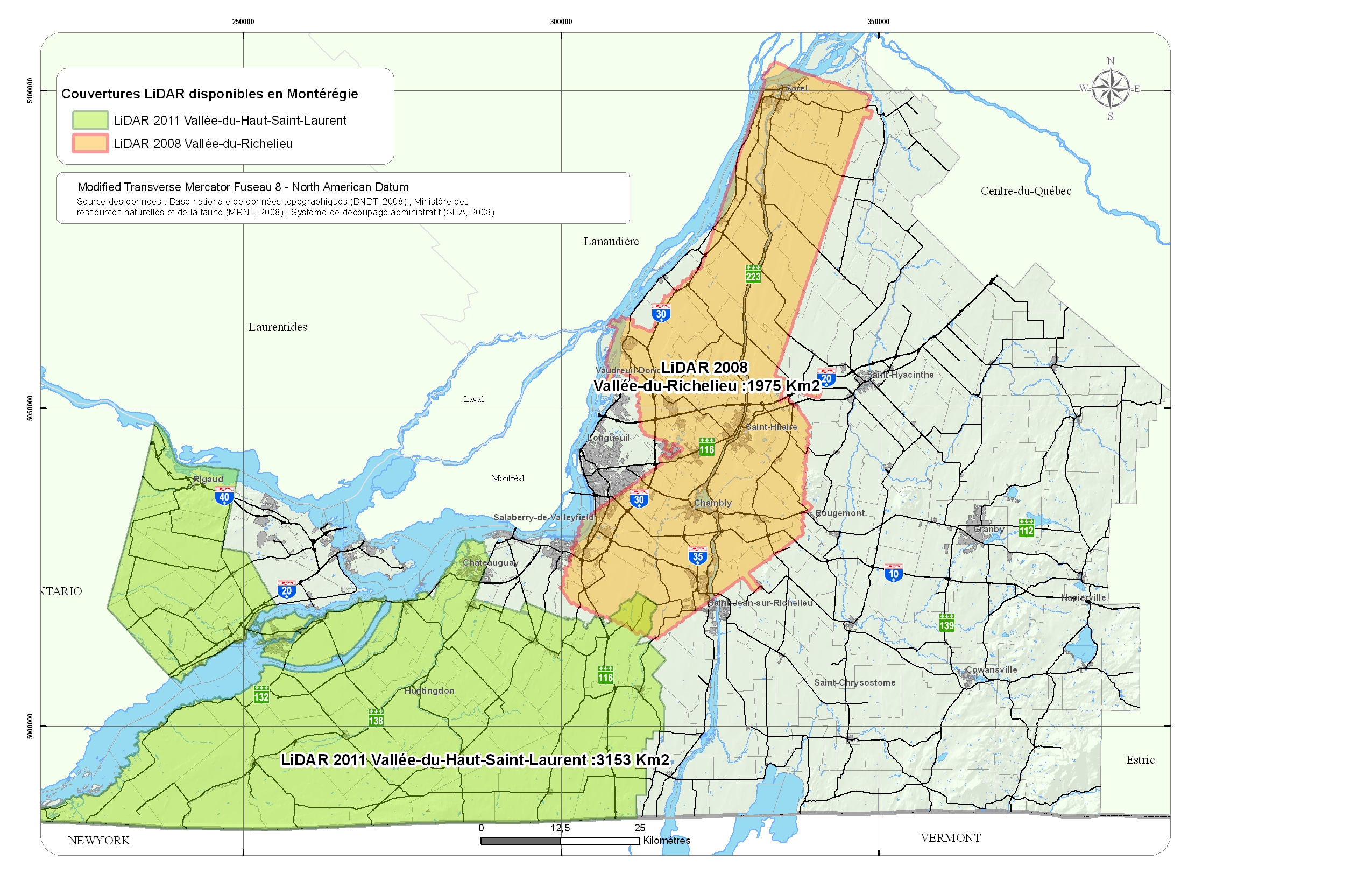
- Vallée-du-Richelieu (2008).
Data available as raw or classified (ground and above-ground).
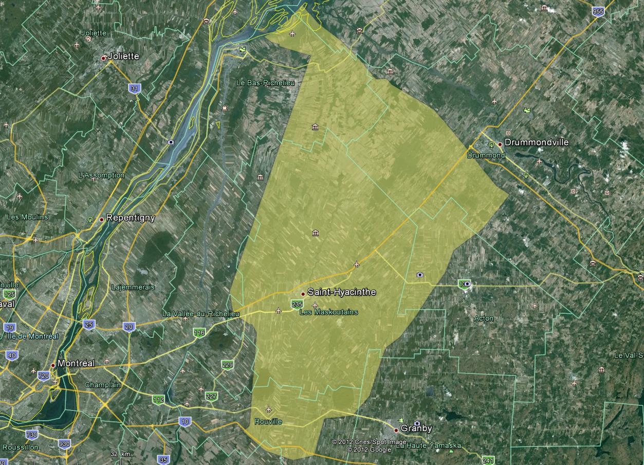
See map. Download the index of tiles (zipped SHP for ArcGIS) - Yamaska (2011).
Data available as raw or classified (ground and above-ground).
See map. Download the index of tiles (zipped SHP for ArcGIS)
If you cannot find the data on Geoindex, please contact the librarian responsible for geospatial data.
Aerial photographs
Quebec Universities' collections of print and digitized aerial photographs of the province of Quebec can now be consulted through the Geophoto module of Geoindex. In addition to these collections, thousands of photos from the ministère de l'Énergie et des Ressources naturelles (MERN) and Bibliotheque et Archives nationales (BAnQ) can also be obtained through Geophoto.
Other important collections of aerial photos covering the province of Quebec and Canada include (note that those photographs must be purchased):
- Geoselec: catalogue of almost 2 million aerial photographs from 1953 to 2021, mostly covering the province of Quebec. These photographs were produced by the goverenment of Quebec and some private organizations.
- National Air Photo Library: the NAPL of Natural Resources Canada archives over 6 million aerial photographs covering all of Canada, some of which date back to the 1920s.
Orthophotos
Orthophotos are digital images based on aerial photographs. Unlike normal photographs, they display true geographic positions, thus allowing to accurately measure distances, by rectifying distortions due to relief and camera tilt.
Orthophotos from the Government of Quebec
Orthophotos collected by the Government of Quebec since 1992 are now avaible on the Données Québec website.
Other collections of orthophotos
We have acquired collections for the following areas. Most orthophotos are directly downloadable from Geoindex, but if you cannot find the data there, please contact the librarian responsible for geospatial data and provide the photo ID numbers (obtained form the appropriate index) as well as the format you require.
Communauté métropolitaine de Montréal (Montreal Metropolitan Area)
We have acquired orthophotos for 2005 (22 cm) , 2009 (10 and 20 cm), 2013 (12 cm), 2016 (20 cm), 2020 (6 cm) and 2023 (25 cm).
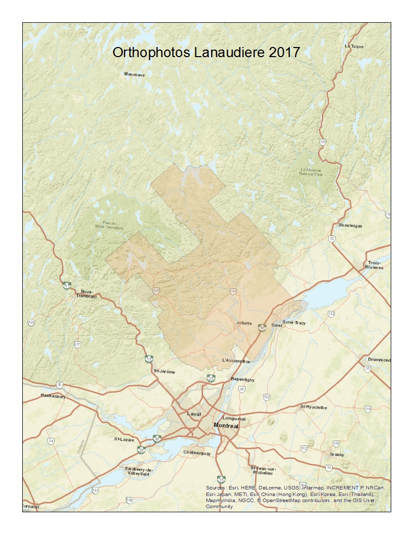
Lanaudiere
This set includes the orthophotos taken in May 2017 in near infrared (NIR) and colour (RGB) in TIFF format at a resolution of 20 cm; .PAR files for 3D visualization; and two sets of mosaics: (2km X 2km, geotiff) and 1:20 000 (JPG2000 and ECW). A digital elevation model (DEM) was alco created based on the photos.
- Map of area
- Index of photos (shapefile)
- Index of 2km X 2km mosaics (shapefile)
- Index of 1: 20,000 mosaics (shapefile)
We also have orthpop[hotos of Lanaudiere for 2024 at a resolution of 20 cm.
Montérégie
| 2014 | 2017 | 2020 | |
|---|---|---|---|
| Date | April-May 2014 | April-July 2017 | Spring 2020 |
| Coverage map | Download 2014 Coverage Map (PDF) | Download 2017 Coverage Map (PDF) | Download 2020 Coverage Map (PDF) |
| Projection | Geographic | NAD83 MTM 8 (CSRS), EPSG:2950 | NAD83 MTM 8 (CSRS), EPSG:2950 |
| Datum | NORTH_AMERICAN_1983 | NORTH_AMERICAN_1983 | NORTH_AMERICAN_1983 |
| INDIVIDUAL ORTHOPHOTOS | |||
| Resolution | 30cm | N/A | N/A |
| Bands | NIR/RGB | N/A | N/A |
| Format | GeoTIFF | N/A | N/A |
| Photogrammetric model (.PAR) | Yes | N/A | N/A |
| Index (shapefile) | Download Index (Shapefile) | N/A | N/A |
| MOSAICS | |||
| Scale/Tile size | 1:20,000 | 5km x 5km | 5km x 5km |
| Resolution | 30cm | 30cm | 20cm |
| Format | ECW/JPG2000 | ECW | ECW/GeoTIFF |
| Index (shapefile) | Download Index (Shapefile) | Download Index (Shapefile) | Download Index (Shapefile) |
This table provides geospatial data coverage information for the years 2014, 2017, and 2020, including details on individual orthophotos and mosaics, such as resolution, bands, format, and available index shapefiles.
Note that we also have acquired orthophotos mosaics for 2023 at a resolution of 20cm.
MRC de Beauharnois-Salaberry
| 2016 | 2019 | |
|---|---|---|
| Date | April 2016 | May 2019 |
| Coverage map | Download 2016 Coverage Map (PDF) | Download 2019 Coverage Map (PDF) |
| Projection | N/A | N/A |
| Datum | N/A | N/A |
| ORTHOPHOTOS | ||
| Resolution | 12 cm | 12 cm |
| Bands | RGB | RGB/IR |
| Format | TIFF | GeoTIFF |
| Photogrammetric model (.PAR) | Yes | Yes |
| Index (PDF) | Download 2016 Index (PDF) | Download 2019 Index Flight Lines (Shapefile) |
| MOSAICS in Large Map Sheets | ||
| Scale/Tile size | 1:10,000 | 1:10,000 |
| Format | ECW (3 bands)/JPG2000 (2 bands) | ECW/JP2G2000 |
| Index (Shapefile) | Download Index (Shapefile) | Download Index (Shapefile) |
| MOSAICS in 1km² Tiles | ||
| Scale/Tile size | 1km square | 1km square |
| Index (Shapefile) | Download 2016 Index (Shapefile) | Download 2019 Index (Shapefile) |
This table presents geospatial data coverage information for the years 2016 and 2019, detailing orthophotos and mosaics, including resolution, bands, formats, and links to coverage maps and shapefile indices.
We also have orthophotos for that MRC for 2022 at a resolution of 10 cm.
Wetlands
The government of Quebec (MELCC) in collaboration with Ducks Unlimited has produced a detailed cartography of wetlands areas of southern Quebec. The products include geospatial data in s geodatabase (.gdb) format; statistical tables describing the surface covered by wetland as well as the types of wetland (bog, fen, marsh, swamp, shallow water). For more details on the project scope and its methodology, please consult the project website. Note that all the metadata and documentation are in French only.
An online map is also available for visualizing the data.
The dataset can be downloaded from Données Québec.
The data that is part of the OGDE is only available to students and faculty of Concordia University. To obtain a dataset, please contact the librarian responsible for geospatial data.
These are some examples of OGDE datasets:
- Southern Ontario Land Resource Information System (SOLRIS)
SOLRIS is a comprehensive landscape scale inventory of southern Ontario's natural, rural and urban areas. Available in SHAPEFILE format. - Provincial Digital Elevation Model
A high resolution raster data set covering the province of Ontario to the 51st parallel. Cell resolutions are 20 metres in northern Ontario and 10 metres in southern Ontario. The DEM is divided up into 150 tiles. - Here is a description of other datasets that are part of the OGDE
LiDAR Data
LiDAR is a laser-based technology that produces clouds of points providing detailled elevation information that can be used to create a Digital Elevation Model (DEM).
A LiDAR dataset covering the the Island of Montreal is now avaible on the city's open data portal. The data was collected in 2015. The data accuracy (planimetry and altimetry) is 20cm. Note that the files are available in a compressed LAZ format. To use the data in ArcGIS or other GIS software, users need to decompress the LAZ files using a software such as LASzip.
Digital Elevation Models (DEMs) based on Montreal LiDAR Data
Based on the 2015 LiDAR data (see above), the City of Montreal's open data portal produced, for each borough:
- Digital Terrain Models (DTM) (bare-ground) -- Formats: LandXMl, CityGML. Accuracy : ±20 cm.
- Digital Surface Models (DSM) (includes buildings) -- Format: Geotiff. Resolution: 1m/pixel
- Canopy Digital Model (Vegetation) -- Format: Geotiff. Resolution: 75cm/pixel
In addition, a research professional from the Department of Geography produced various Digital Elevation Models (DEMs) covering the Island of Montreal:
- A high-resolution (1 m) bare-ground DEM (index) (map)
- A lower resolution (10 m) bare-ground DEM
- A high-resolution (1 m) DEM showing buidings and ground (index) (map)
- Hillshade files for all the DEMs mentioned above
City of Montreal Cartographic Plans (Cartographie de base)
The City of Montreal detailed cartographic plans, at the scale of 1:1000, contains building footprints, elevation spot heights, streets , sidewalks, canopy, and other detailed features in Autocad format (DGN, DWG). The geographic coverage includes the whole island of Montreal. The date of production varies depending on the area of interest.
This dataset is available freely on the City of Montreal open data portal. To download individual tiles, please use the interactive map (outil de cartographie).
Transit Data - Societé de Transport de Montréal
The STM transit geospatial data constist of bus stop locations, bus routes, metro stops, metro lines, commuter train stops and lines, in General Transit Feed Specification (GTFS) format. Bus lines and bus stops are also available in shapefile (shp) format. You can download these datasets, from the open data section of the STM webiste.
Land Use and Development Plan (Plan métropolitain d'aménagement et de développement (PMAD) -- Communauté métropolitaine de Montréal (CMM))
The "Données géoréférencées" page of the CMM offers various datasets including:
- Land use datasets for the Greater Montreal Area
- Data related to the most recent (2012) metropolitan development plan (Plan métropolitain d'aménagement et de développement (PMAD) --as well as the documentation and PDF maps.
- Major Roads (réseau artériel métropolitain)
- Forest cover
- Canopy data
- Small scale orthophotographs
QGIS
QGIS is a free, open-source software used to view, interpret, and analyse geospatial data. It is installed on all computers in the Mexico Reading Room (LB-445).
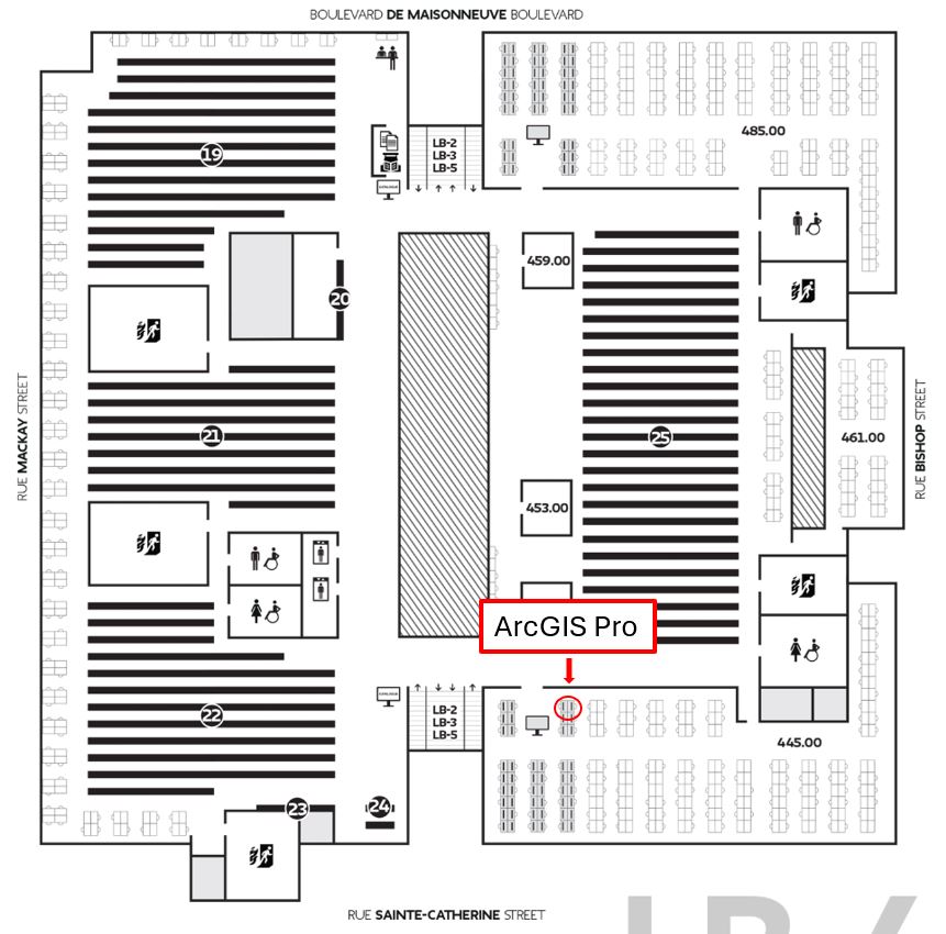
ArcGIS Pro
ArcGIS Pro is a fully operational Geographic Information System that is used to view, interpret, and analyse geospatial data. It can be used to create maps, calculate spatial statistics, and much more. The ArcGIS Pro software is installed on stations 445.031 and 445.048 located in the Mexico Reading Room (LB-445) on the 4th floor of the Webster Library.
Students who are enrolled in courses offered by Concordia's Department of Geography, Planning and Environment can use the ArcGIS account provided by the Department.
Students who are not currently enrolled in that Department's courses may request an ArcGIS account by filling this form. Please allow one business day for the creation of your account. Once your account is created, you will receive an invitation email from ESRI with your user name. Note that the ArcGIS account is limited to the 2 library stations.
If you have an issue with your account, please contact m.burelli@concordia.ca
ArcGIS Explorer
ArcGIS Explorer is a free software that is used to view and do basic interpretations of geospatial data. It cannot be used to analyse the data. ArcGIS Explorer is available to download.
Open Source Geographic Information System Applications
There are several open source geographic information system applications available for download. Please note that most of the open source GIS applications do not have the same level of functionality as ArcGIS. Here is a list of open source GIS applications.
If you need information about the products listed on this page, or if you want to find additional geospatial data, please contact Alex Guindon (alex.guindon@concordia.ca).